Nestled amidst the towering peaks of the Indian Himalayas, a collection of awe-inspiring roads ascend to dizzying altitudes, marking some of the world’s highest motorable passages. These elevated arteries of human connectivity and adventure, collectively known as the “highest motorable roads in India,” beckon to the intrepid souls who seek to conquer their heights and embrace the challenge of riding through the thin air of the mountains. From the thrill of conquering steep ascents to the wonder of gazing upon breathtaking vistas, these roads offer a unique blend of hardship and reward, where every twist and turn carries the whispers of both nature’s majesty and mankind’s perseverance. Embarking on a journey along these roads means not only navigating the treacherous terrains and the uncertain weather but also forging a connection with the history, geography, and the indomitable spirit of the land. In this exploration, we delve into the heart of these winding pathways, uncovering the stories they tell and the adventures they promise at altitudes where the sky and earth seem to meet.
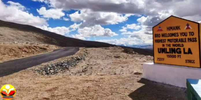
1) Umling La – 19,300 to 19,500 feet (approximately 5,900 to 5,950 meters)
Umling La is often regarded as one of the highest motorable passes in the world, situated in the Ladakh region of the Indian state of Jammu and Kashmir. This pass has gained fame for its remarkable altitude and the challenging journey it offers to adventurers and motorcyclists. While precise measurements can vary slightly, Umling La is generally considered to be around 19,300 to 19,500 feet (approximately 5,900 to 5,950 meters) above sea level.
Here are some key details and information about Umling La:
Location: Umling La is located in the Changthang region of Ladakh, within the Union Territory of Jammu and Kashmir. It lies to the southeast of Leh, the capital of Ladakh, and is situated near the Hanle village.
Altitude: As mentioned earlier, the pass’s altitude places it among the highest motorable roads in the world. The extreme elevation presents challenges such as reduced oxygen levels, making it important for travelers to acclimatize properly.
Accessibility: Reaching Umling La requires a journey through remote and challenging terrain. The road leading to the pass is mostly unpaved and can be rough, especially in sections that experience snowfall and erosion due to harsh weather conditions.
Weather Conditions: The weather at Umling La can be extremely unpredictable and harsh. Even during the summer months, the pass can experience rapid weather changes, including sudden snowfall and strong winds.
Acclimatization: Due to the high altitude, acclimatization is crucial for travelers before attempting to cross Umling La. Altitude sickness is a real concern at such elevations, and proper acclimatization reduces the risk of health complications.
Adventure and Challenges: Crossing Umling La is an adventure that requires both physical and mental endurance. The challenging terrain, lack of facilities, and the altitude’s impact on the human body make this journey a true test of one’s skills and resilience.
Permits: Traveling to certain regions of Ladakh, including Umling La, might require obtaining Inner Line Permits due to their proximity to international borders. These permits are usually arranged through local authorities or online portals.
Scenic Beauty: Despite the challenges, the journey to Umling La rewards travelers with breathtaking views of the surrounding landscapes. The stark beauty of the Ladakhi terrain, the vast expanse of the Changthang plateau, and the Himalayan peaks in the distance are sights that remain etched in memory.
Remote Location: Umling La is in a remote area with limited human habitation. Travelers should be prepared for minimal facilities and accommodations along the way.
Respect for Nature: Travelers venturing into such pristine and ecologically sensitive areas should prioritize responsible tourism, leaving no trace of their presence and respecting the local environment and culture.
In conclusion, Umling La represents both a physical and mental journey into the heart of the Himalayas, challenging adventurers to test their limits and embrace the raw beauty of high-altitude landscapes. It’s a testament to human determination and a connection to the world’s most majestic heights.
2) Dungri La or Mana Pass – 18,399 feet (5,608 meters)
Dungri La, also known as Mana Pass, is situated in the Uttarakhand region of northern India. It connects the Indian state of Uttarakhand with the Tibet Autonomous Region of China. The pass is close to the town of Mana, which is the last village on the Indian side before the border.
Altitude: The pass is situated at an altitude of approximately 18,399 feet (5,608 meters) above sea level. This makes it one of the high-altitude passes in the region.
Accessibility: The road leading to Dungri La or Mana Pass is known for its challenging terrain. It is generally not open to regular vehicular traffic and is more often used for trekking purposes. The road is rocky and difficult to navigate, especially in adverse weather conditions.
Trekking Route: Dungri La is often accessed by trekkers and adventurers who embark on the Gangotri-Mana Pass Trek. This trek offers stunning views of the Himalayan peaks and takes you through remote and picturesque landscapes. The trek is considered challenging due to its altitude and the ruggedness of the terrain.
Cultural Significance: Mana, the last village before the pass, holds cultural significance for being the last inhabited village on the Indian side before the border. It’s known for its association with the Pandavas from the Hindu epic Mahabharata.
Weather and Conditions: Due to its high altitude, Dungri La or Mana Pass experiences harsh weather conditions. Snow and unpredictable weather patterns are common, making proper gear and preparation essential for trekkers and travelers.
Permit Requirements: Given its proximity to the international border, accessing Dungri La or Mana Pass might require obtaining permits from local authorities. These permits are meant to regulate movement in the border regions and can usually be arranged through the appropriate channels.
Remote Location: The pass is situated in a remote area with limited facilities. Trekkers and adventurers should be prepared for basic accommodations and carry necessary supplies.
Natural Beauty: The journey to Dungri La offers breathtaking views of the surrounding Himalayan landscapes, including snow-capped peaks, alpine meadows, and pristine valleys.
Please keep in mind that conditions and regulations can change, and it’s important to gather the most recent and accurate information before planning any trips to Dungri La or Mana Pass in Uttarakhand.
3) MARSIMIK LA, JAMMU & KASHMIR – 18,314 feet (5,582 meters)
Marsimik La is situated in the Chang-Chemno Range of the Himalayas, near the Pangong Lake in the Ladakh region of Jammu and Kashmir. It’s a remote area with limited human habitation and infrastructure.
Altitude: The pass is often claimed to be at an elevation of around 18,314 feet (5,582 meters) above sea level, though precise measurements might vary slightly. This high altitude presents challenges related to reduced oxygen levels.
Accessibility: The road leading to Marsimik La is a rugged and challenging terrain, mostly suited for experienced off-road drivers and adventurers. It’s often used by trekkers and motorcyclists who are seeking an adrenaline-pumping journey.
Trekking and Motorcycling: Marsimik La is a popular destination for trekkers and motorcyclists. The journey to the pass involves crossing difficult terrain, crossing streams, and navigating rocky paths. It’s a test of both physical endurance and riding skills.
Weather Conditions: Due to its high elevation, the pass experiences harsh weather conditions. Snow and extreme cold are common even during the summer months. Trekkers and adventurers should be well-prepared for varying weather conditions.
Acclimatization: Given the high altitude, proper acclimatization is crucial before attempting to cross Marsimik La. Altitude sickness is a real concern, and travelers should ascend gradually to minimize health risks.
Remote Location: Marsimik La is situated in a remote and sparsely populated region. Travelers should be prepared for minimal facilities and accommodations along the route.
Permits: Due to its proximity to international borders, traveling to Marsimik La might require obtaining Inner Line Permits from local authorities. These permits are usually arranged before entering restricted regions.
Natural Beauty: The journey to Marsimik La offers awe-inspiring views of the Himalayan landscapes. The rugged mountains, vast valleys, and the pristine beauty of the region make the arduous journey worth it.
Responsible Tourism: Travelers should prioritize responsible tourism, respecting the environment and local culture. Leaving no trace and minimizing the impact on the fragile ecosystem is essential in such remote areas.
Remember that Marsimik La is a challenging destination, and those considering the journey should be experienced and well-prepared for the rigors of high-altitude travel. Always ensure you have the latest information and necessary preparations before embarking on any trip to Marsimik La in Jammu and Kashmir.
4) Photi La, Jammu & Kashmir – 18,124 ft 5,524 metres
Photi La is a high mountain pass located in the union territory of Jammu and Kashmir, India. It’s one of the highest drivable roads in the world and is situated at an elevation of approximately 5,524 meters above sea level. The pass is located in the Ladakh region and connects the valleys of the Markha River and the Indus River.
The pass is not easily accessible and is generally considered as one of the toughest passes in the region due to its high altitude and rough terrain. The weather can be quite unpredictable and often severe, with heavy snowfall and freezing temperatures being common during the winter season.
Despite these challenges, the pass offers breathtaking views of the surrounding valleys and mountains, making it a popular destination for adventurous travelers and photographers. Please note that due to its high elevation, it’s important to be prepared for possible altitude sickness if you’re planning to visit this area.
5) DONKIA LA, SIKKIM – 18,156.2 FT 5,534 meters
Donkia La, also known as Donkia Pass, is a mountain pass located in the Indian state of Sikkim. It’s situated at an elevation of approximately 5,534 meters above sea level. This pass is not far from the borders of Bhutan and Tibet and provides a strategic route in the region.
This pass is one of the highest motorable roads in the eastern Himalayas. However, it’s important to note that due to its high altitude, harsh weather conditions, and rough terrain, it’s considered a challenging route to traverse.
Donkia La offers a stunning view of the mighty Kanchenjunga, the third highest mountain in the world, along with other snow-capped peaks of the Himalayan range. The pass is also known for its rich biodiversity including various species of high-altitude flora and fauna.
Due to its strategic location, access to Donkia La is restricted and special permits are required to visit this area. It’s advised to check the latest regulations and weather conditions before planning a trip to this region.
6) Kaksang La, Jammu & Kashmir – 17,842 ft 5,438 meters
Kaksang La, also known as Kaksang Pass, is an elevated mountain pass located in the Ladakh region of the Indian state of Jammu and Kashmir. The pass is positioned at a staggering altitude of about 5,438 meters above sea level.
Kaksang La is considered one of the highest motorable roads in the world. The pass provides breathtaking views of the surrounding Himalayan peaks and is popular among adventure enthusiasts who relish the challenge of high-altitude driving.
Due to its extreme altitude, the pass experiences harsh weather conditions, with heavy snowfall in the winter months often leading to road closures. However, during the summer months, the pass becomes accessible and offers a unique and thrilling experience to travelers.
Kaksang La is relatively less known compared to other high passes in Ladakh such as Khardung La or Chang La and sees fewer visitors. This makes it a serene and unspoiled spot for those seeking solitude and an intimate experience with nature.
As with all high-altitude regions, it’s important to be mindful of altitude sickness and to acclimatize properly before attempting to cross the pass.
7) Chang La, Jammu & Kashmir – 17,688 ft 5,360 meters
Chang La is a high mountain pass in Ladakh, a union territory in the northern Indian region of Jammu and Kashmir. It’s one of the highest drivable roads in the world, situated at an elevation of approximately 5,360 meters ( 17,688 feet) above sea level.
The pass is named after a Sadhu named Changla Baba, to whom the pass temple is dedicated. It’s a critical gateway for the Changthang Plateau situated in the Himalayas. The landscapes are amazing, and the region is known for its barren, moonlike terrain.
The road to Chang La is a tight winding route maintained by the Border Roads Organisation, a branch of the Indian Army. It’s considered a challenging drive because of its high elevation and the inclement weather conditions common in the area.
Chang La is on the route to Pangong Tso (Lake) from Leh. The first town after the pass is Tangste, where most of the accommodations are available. Despite the harsh conditions, a number of species survive in the region, including the rare and charismatic snow leopard.
It’s important to note that due to the high altitude, oxygen is in short supply and altitude sickness is common among unacclimated visitors. It’s recommended to be properly acclimated, hydrated, and prepared for extreme weather when planning a visit.
One should also keep in mind that due to its strategic location near the Line of Actual Control, the region is controlled by the Indian Army, and any travel requires permission from Indian authorities.
8) Khardung La, Jammu & Kashmir – Approximately 5,359 meters (17,582 feet)
Khardung La is a significant mountain pass located in the Ladakh region of the Indian union territory of Jammu and Kashmir. Often erroneously claimed as the highest motorable road in the world, Khardung La sits at an elevation of approximately 5,359 meters (17,582 feet) above sea level.
The pass lies north of Leh and is the gateway to the Shyok and Nubra valleys. The beautiful Siachen Glacier lies partway up the latter valley. Built in 1976, it was opened to public motor vehicles in 1988 and has since seen many motor vehicle, motorbike and mountain biking expeditions. Maintained by the Border Roads Organisation, the pass is strategically important to India as it is used to carry supplies to the Siachen Glacier.
The road journey to Khardung La is a memorable one, with stunning views of the never-ending snowy landscape. The weather can be unpredictable and can change suddenly from sunny skies to storms. This area is particularly treacherous during winter and extra care should be taken while traversing this pass.
Just like other high-altitude destinations in the region, Khardung La also poses the risk of altitude sickness, thus it’s recommended to be properly acclimated before making the journey. There are facilities to provide emergency medical help in case of any health issues.
In terms of permits, as it is a sensitive border area, international visitors need to get an Inner Line Permit (ILP) to visit Khardung La. Indian citizens do not require ILP but must carry a valid photo ID to prove their nationality.
9) Tanglang La, Jammu & Kashmir – Approximately 5,328 meters (17,480 feet)
Tanglang La is a high mountain pass located in the Ladakh region of the Indian union territory of Jammu and Kashmir. It is positioned at an elevation of approximately 5,328 meters (17,480 feet) above sea level. This makes Tanglang La one of the world’s highest motorable passes.
It’s situated along the Leh-Manali Highway and serves as a gateway between the Indus Valley and the Tsarap Chu Valley. The pass offers breathtaking views of the surrounding landscape which is a mix of rugged mountainous terrain and sweeping valleys.
The road through Tanglang La is generally open between May or June and October or November when the snow is cleared, and it’s considered as one of the most difficult passes to cross, due to the harsh weather conditions and high altitude. The Border Roads Organisation, under the Indian Army, maintains the pass and the roads leading to it.
Visitors should be aware that the oxygen level at the top of the pass is about half of that at sea level, making it a challenging environment for those not acclimated to such high altitudes. Symptoms of altitude sickness are quite common among unacclimated visitors. Therefore, it’s always recommended to acclimatize before making the journey to the pass.
No special permit is required to visit Tanglang La for Indian citizens, but a valid photo ID is required. However, international tourists will need to secure a Protected Area Permit (PAP) to visit this area due to its proximity to the border.
10) Wari La, Jammu & Kashmir – Approximately 5,312 meters (17,427 feet)
Wari La is a high mountain pass situated in the Himalayan region of the Indian union territory of Jammu and Kashmir. It’s located at an elevation of approximately 5,312 meters (17,427 feet) above sea level, making it one of the highest motorable passes in the world.
The pass lies between the Nubra Valley and the Indus Valley, connecting the towns of Khalsar and Sakti. It is considered as one of the toughest passes in the region due to its steep gradients, narrow roads, and harsh weather conditions. The road conditions are often challenging and require a capable vehicle and an experienced driver.
The road through Wari La is generally open during the summer months, from around June to October, depending on the weather conditions. It’s maintained by the Border Roads Organisation of the Indian Army. During the winter months, the pass is typically closed due to heavy snowfall and icy conditions.
As with other high-altitude destinations in the region, altitude sickness can be a concern for visitors to Wari La. It’s recommended to spend a few days acclimatizing in Leh or another high-altitude town before attempting to cross the pass.
For Indian citizens, no special permit is required to visit Wari La, but a valid photo ID is essential. For foreign nationals, a Protected Area Permit (PAP) is required due to its proximity to the border.


